The Golden Circle


An 1800 kilometer fall road trip around the Yukon territory and Alaska including Tombstone Territorial Park, Annie Lakes, the Haines Highway, Kluane National Park, Carcross, Dawson City, and the Southern Lakes
Un viaje por carretera otoñal de 1800 kilómetros alrededor del territorio de Yukon y Alaska, incluido el Parque Territorial Tombstone, Annie Lakes, Haines Highway, Kluane National Park, Carcross, Dawson City y Southern Lakes
by/por Victor Aerden
We meet Andrew, the owner of Overland Yukon, outside the small airport in Whitehorse, Yukon. The fierce autumn chill has arrived quickly, and as he hands us the keys to a fully outfitted Jeep Rubicon, he asks if we have plenty of layers, maps, a GPS, and bear spray. Then he smiles.
Nos encontramos con Andrew, el propietario de Overland Yukon, fuera del pequeño aeropuerto de Whitehorse, Yukon. El feroz frío otoñal ha llegado rápidamente, y mientras nos entrega las llaves de un Jeep Rubicon completamente equipado, pregunta si tenemos muchas capas, mapas, un GPS y spray para osos. Luego sonríe.

He begins walking us through the specifics of the vehicle which will be our home for the next two weeks as we make a 1,800 kilometer journey around The Yukon, the smallest and westernmost of Canada’s three territories, chasing fall colors and adventure.
Él comienza a explicarnos los detalles del vehículo que será nuestro hogar durante las próximas dos semanas mientras realizamos un viaje de 1.800 kilómetros por el Yukón, el más pequeño y occidental de los tres territorios de Canadá, persiguiendo los colores del otoño y la aventura.


After bidding Andrew farewell we set out South and up onto Annie Lake Road and the Carcross / Tagish First Nations land. Pugh Peak and Mt. Gilliam tower over what feels like a dozen perfect campsites in a textbook perfect glacier-carved “U” valley.
Después de despedirnos de Andrew, nos dirigimos hacia el sur y subimos por Annie Lake Road y la tierra de las Primeras Naciones Carcross / Tagish. Pugh Peak y Mt. Gilliam se elevan sobre lo que se siente como una docena de campings perfectos en un valle en forma de “U” tallado por un glaciar perfecto como un libro de texto.
We settle on a riverside site under a bright grove of yellow aspens, quickly make a fire, and open two Thirst Aid Kit beers from Yukon Brewing to celebrate the first night of our journey.
We sleep like babies in our roof top tent.
Nos instalamos en un sitio junto al río bajo una arboleda brillante de álamos amarillos, rápidamente hacemos un fuego y abrimos dos cervezas Thirst Aid Kit de Yukon Brewing para celebrar la primera noche de nuestro viaje.
Dormimos como bebés en nuestra carpa en la azotea.


The following day we cross a vast desert of sand dunes that appear out of place this far norther. The dunes are the remains of an ancient, now-dry, glacial lake-bed, and mountains in the distances that are now covered by bright yellow trees was once the lakeshore.
Al día siguiente cruzamos un vasto desierto de dunas de arena que aparecen fuera de lugar tan al norte. Las dunas son los restos de un antiguo lecho de un lago glacial, ahora seco, y montañas en las distancias que ahora están cubiertas por árboles de color amarillo brillante fue una vez la orilla del lago.


We then enter a sleepy tourist waystop called Carcross that was originally called “Cariboo Crossing” because of the large number of woodland Caribou that frequent the area. Now it is the gateway to the Southern Lakes area.
Luego ingresamos a una tranquila parada turística llamada Carcross que originalmente se llamaba "Cariboo Crossing" debido a la gran cantidad de caribúes boscosos que frecuentan la zona. Ahora es la puerta de entrada al área de Southern Lakes.
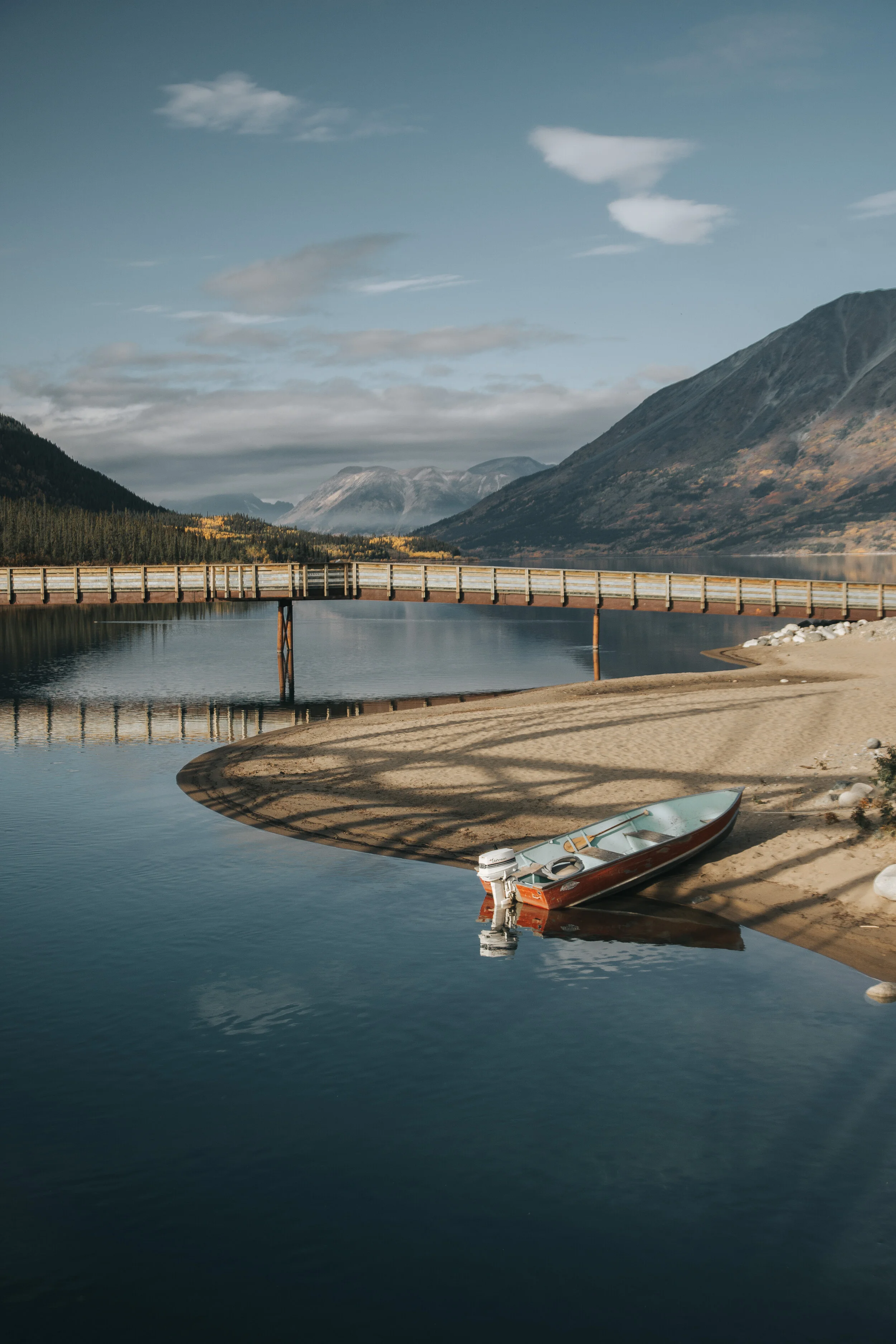

We visit the old general store and buy icecream before walking along the river to the White Pass and Yukon Route (“WP&Y”) railway trestle bridge that crosses the narrow straight between Bennet Lake and Nares Lake.
Visitamos la antigua tienda general y compramos helado antes de caminar a lo largo del río hasta el puente de caballete del ferrocarril White Pass y Yukon Route ("WP&Y") que cruza la estrecha recta entre el lago Bennet y el lago Nares.

The WP&Y was built to connect Skagway, Alaska and Whitehorse to carry prospectors to the Dawson gold fields and the gold itself to southern, west coast markets in Canada and the United States.
Leaving town we head south along the vibrant aqua Tagish Lake and make camp at the Conrad Historic Townsite and Campground. The surrounding mountains are dusted white, and ringed in yellow and orange on lower elevations.
El WP&Y se construyó para conectar Skagway, Alaska y Whitehorse para llevar a los buscadores a los campos de oro de Dawson y el oro mismo a los mercados de la costa sur y oeste de Canadá y Estados Unidos.
Al salir de la ciudad, nos dirigimos hacia el sur a lo largo del vibrante lago Tagish y acampamos en Conrad Historic Townsite and Campground. Las montañas circundantes están cubiertas de polvo blanco y están rodeadas de amarillo y naranja en las elevaciones más bajas.

The following day we continued down the Klondike Highway, stopping often to take photos before turning off onto a dirt road that climbs halfway up Paddy Peak where we stop to make camp for the night.
Al día siguiente continuamos por la autopista Klondike, deteniéndonos a menudo para tomar fotos antes de desviarnos hacia un camino de tierra que sube hasta la mitad de Paddy Peak, donde paramos para acampar para pasar la noche.

The following day we set out on foot to climb Paddy Peak itself. Paddy Peak is the highest mountain south of Carcross along the Klondike Highway, and from its summit we can see in every direction the vast wilderness of The Yukon and its glaciers, mountains, and lakes including Bennet and Tutshi, and some like one just below the summit which remain unnamed.
Al día siguiente salimos a pie para escalar el propio Paddy Peak. Paddy Peak es la montaña más alta al sur de Carcross a lo largo de la autopista Klondike, y desde su cima podemos ver en todas direcciones el vasto desierto de El Yukón y sus glaciares, montañas y lagos, incluidos Bennet y Tutshi, y algunos como uno justo debajo del cumbre que permanecen sin nombre.


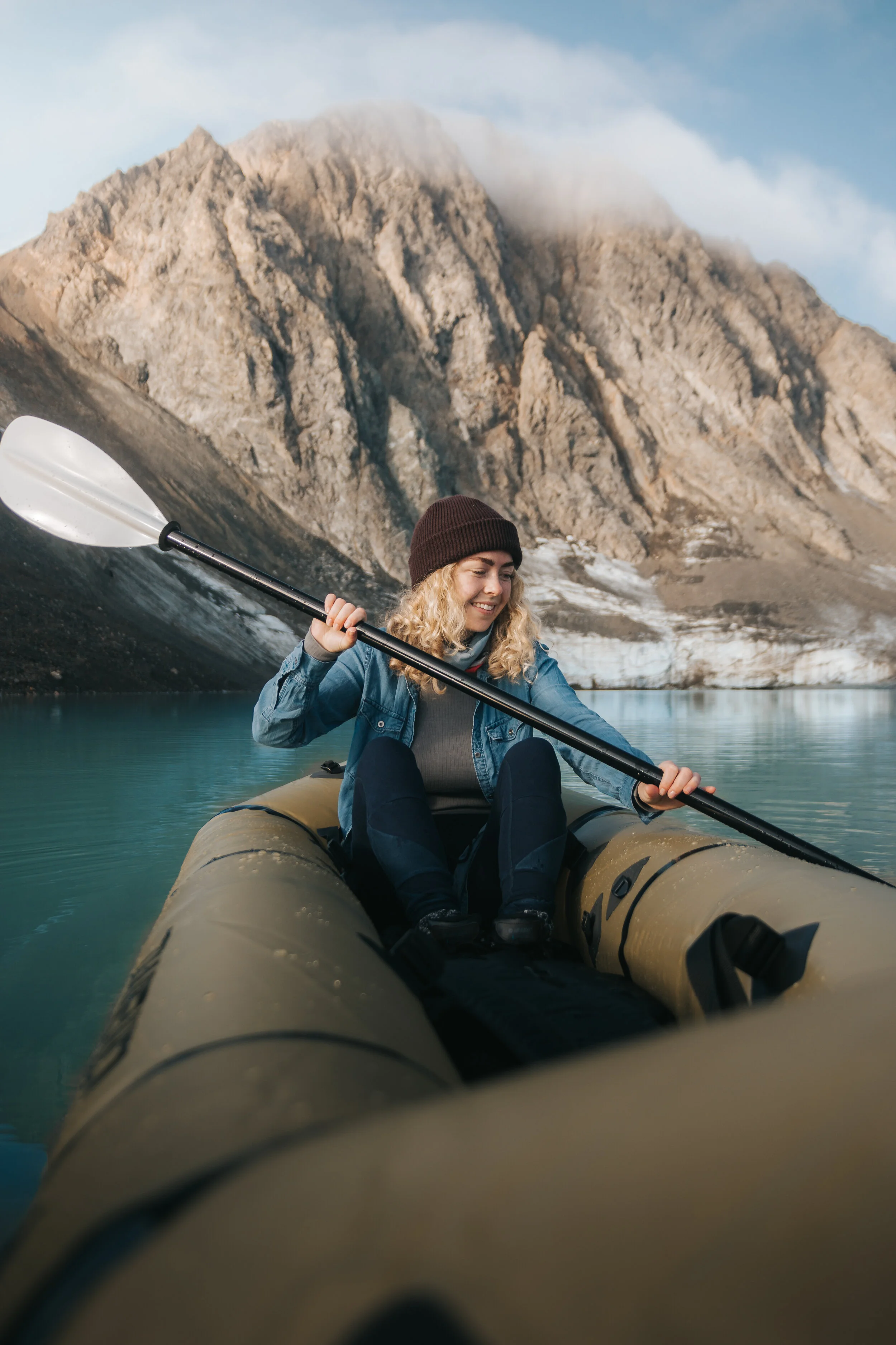
We decide to take our packraft out on this unnamed sapphire lake and let the cool afternoon winds push us slowly past massive, glacier-carved spires.
Decidimos llevar nuestra balsa de carga a este lago de zafiro sin nombre y dejar que los fríos vientos de la tarde nos empujen lentamente más allá de enormes agujas talladas por glaciares.

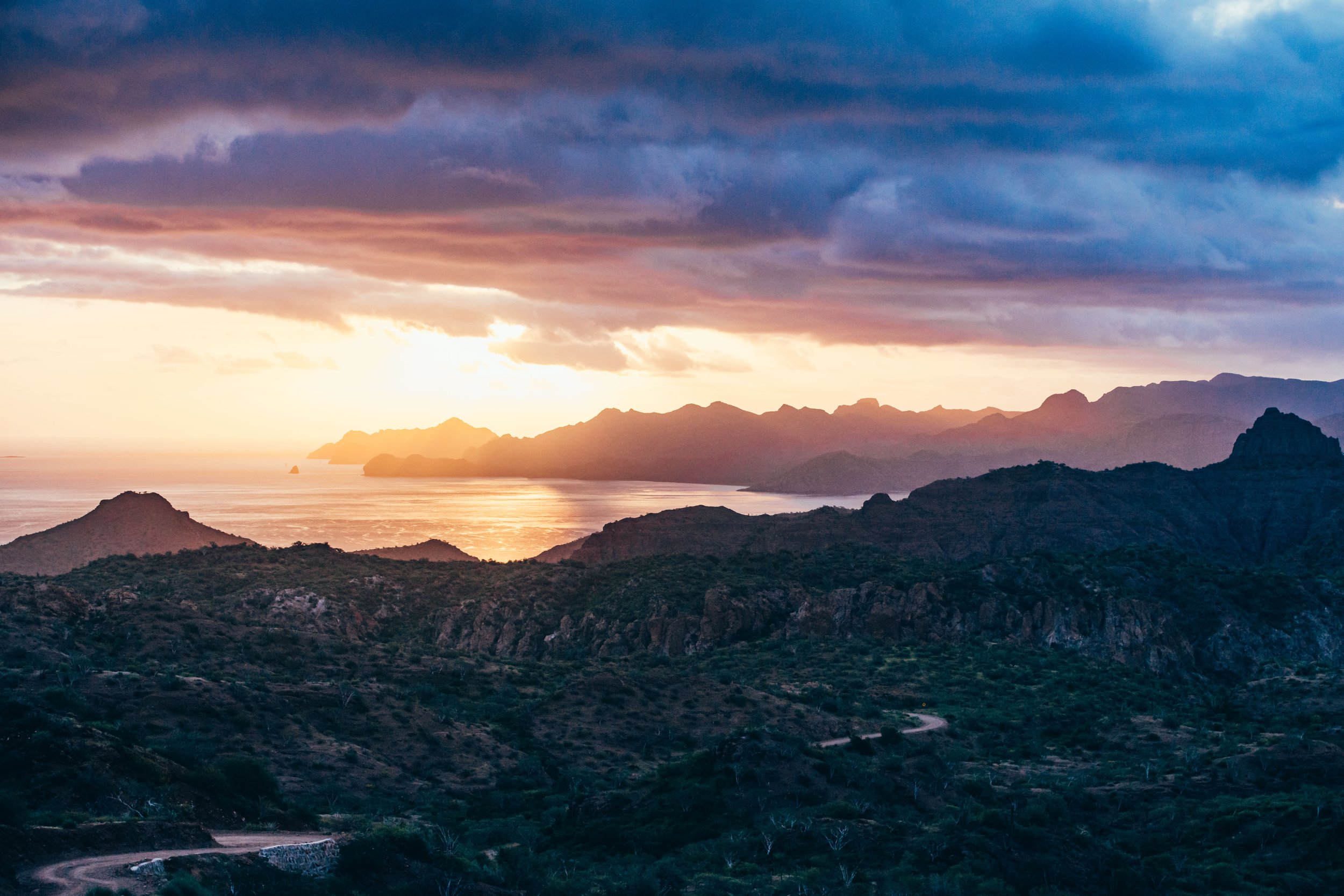
The next day as we continue toward Skagway we cross over White Pass (873 meters) alongside the railroad which was built here in 1898 during the gold rush. Here a sign marks the boundary between Canada and the United States. I think it would be hard to find a prettier (and quieter) border crossing than this one.
Al día siguiente, mientras continuamos hacia Skagway, cruzamos White Pass (873 metros) junto al ferrocarril que se construyó aquí en 1898 durante la fiebre del oro. Aquí un letrero marca el límite entre Canadá y Estados Unidos. Creo que sería difícil encontrar un cruce fronterizo más bonito (y más tranquilo) que este.

Skagway itself is a beautiful old gold rush town, with historic storefronts and raised wooden walkways. It is a popular stop for Alaska Cruises, and has become a tourism hub for the region offering tours and several more modern hotels, but still retains its original, rustic, and gritty feel and saloons offering hefty pours of whiskey and rye.
Skagway en sí es una hermosa ciudad antigua de la fiebre del oro, con escaparates históricos y pasarelas de madera elevadas. Es una parada popular para los cruceros por Alaska y se ha convertido en un centro turístico para la región que ofrece recorridos y varios hoteles más modernos, pero aún conserva su sensación original, rústica y arenosa, y los salones ofrecen copiosos tragos de whisky y centeno.

From Skagway we take the ferry to Haines, AK. The only road into Haines is from Canada, and it is smaller and less developed as Skagway, with more of a salty, fishing community, as the salmon runs are world-famous and with them come bald eagles and grizzlies in abundance.
Desde Skagway tomamos el ferry a Haines, AK. El único camino hacia Haines es desde Canadá, y es más pequeño y menos desarrollado como Skagway, con una comunidad pesquera más salada, ya que los salmones son mundialmente famosos y con ellos vienen águilas calvas y osos pardos en abundancia.


We head into The Chilkoot Bald Eagle Reserve where we see more eagles than we could count and several bears, all set against the breathtaking fjord and lush temperate rainforest speckled with fall colors.
Nos dirigimos a la reserva del águila calva de Chilkoot, donde vemos más águilas de las que podríamos contar y varios osos, todos contra el impresionante fiordo y la exuberante selva tropical templada salpicada de colores otoñales.

From Haines we set out into the Southern Lakes and Kluane National Park.
Desde Haines nos dirigimos hacia los lagos del sur y el parque nacional de Kluane.


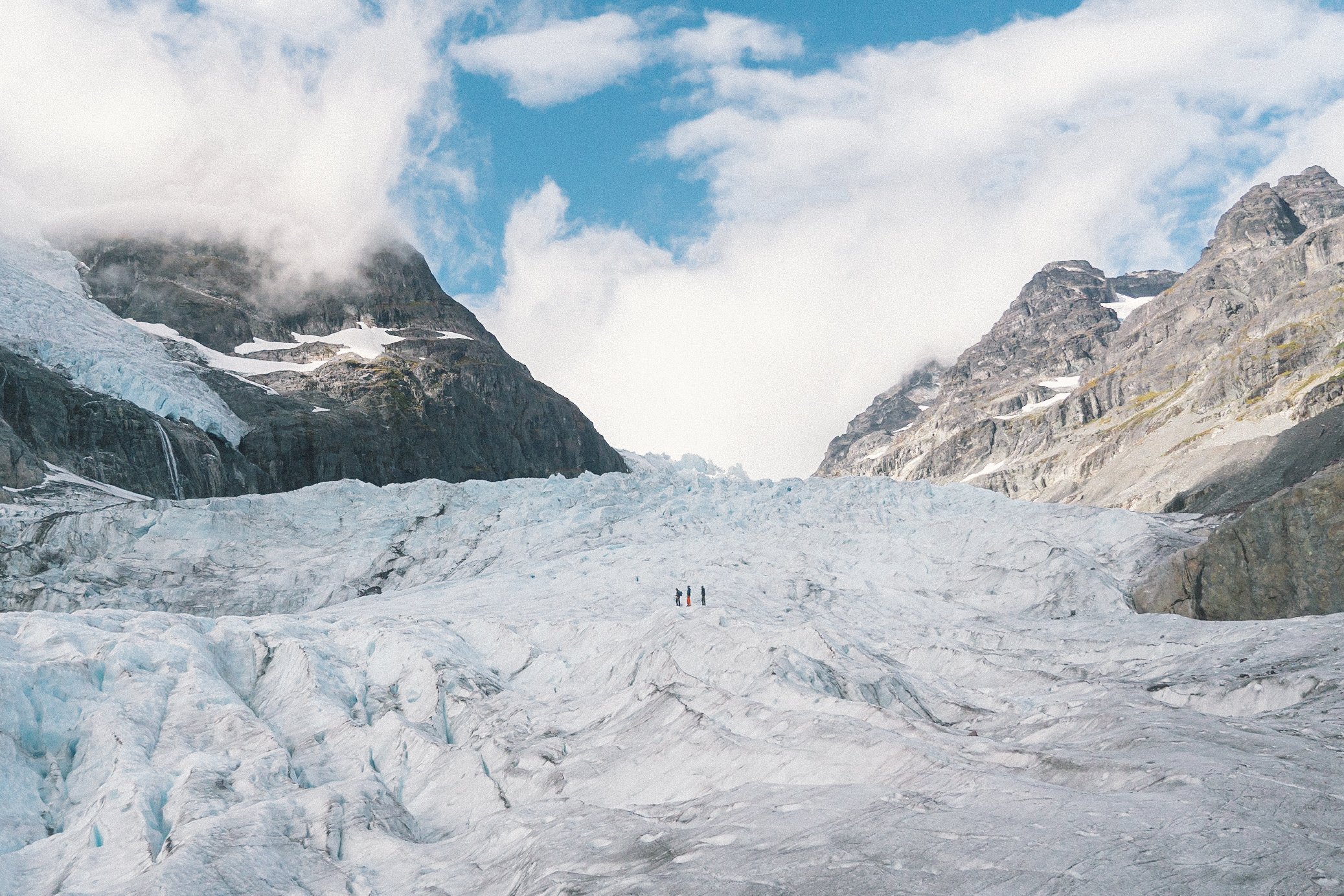
Kluane is home to Canada’s highest peaks - Mount Logan being the tallest of them, at just under 6000 meters. It is said to have the world’s largest base circumference of any non-volcanic mountain and is also home to the world’s largest non-polar icefields many of which are over a kilometer deep.
Kluane es el hogar de los picos más altos de Canadá, siendo el Monte Logan el más alto de ellos, con poco menos de 6000 metros. Se dice que tiene la circunferencia de base más grande del mundo de cualquier montaña no volcánica y también alberga los campos de hielo no polares más grandes del mundo, muchos de los cuales tienen más de un kilómetro de profundidad.

Out of Haines Junction we take an airplane tour over the national park, Mount Logan, and the adjacent glaciers, valleys, and ice fields of the St. Elias Range. The scale of the place defies description, and is a place where glaciers like the Kaskawulsh travel for 50 miles and reach widths of up to 4 miles.
Saliendo de Haines Junction, realizamos un recorrido en avión por el parque nacional, el monte Logan y los glaciares, valles y campos de hielo adyacentes de la cordillera St. Elias. La escala del lugar desafía toda descripción, y es un lugar donde los glaciares como el Kaskawulsh viajan por 50 millas y alcanzan anchos de hasta 4 millas.


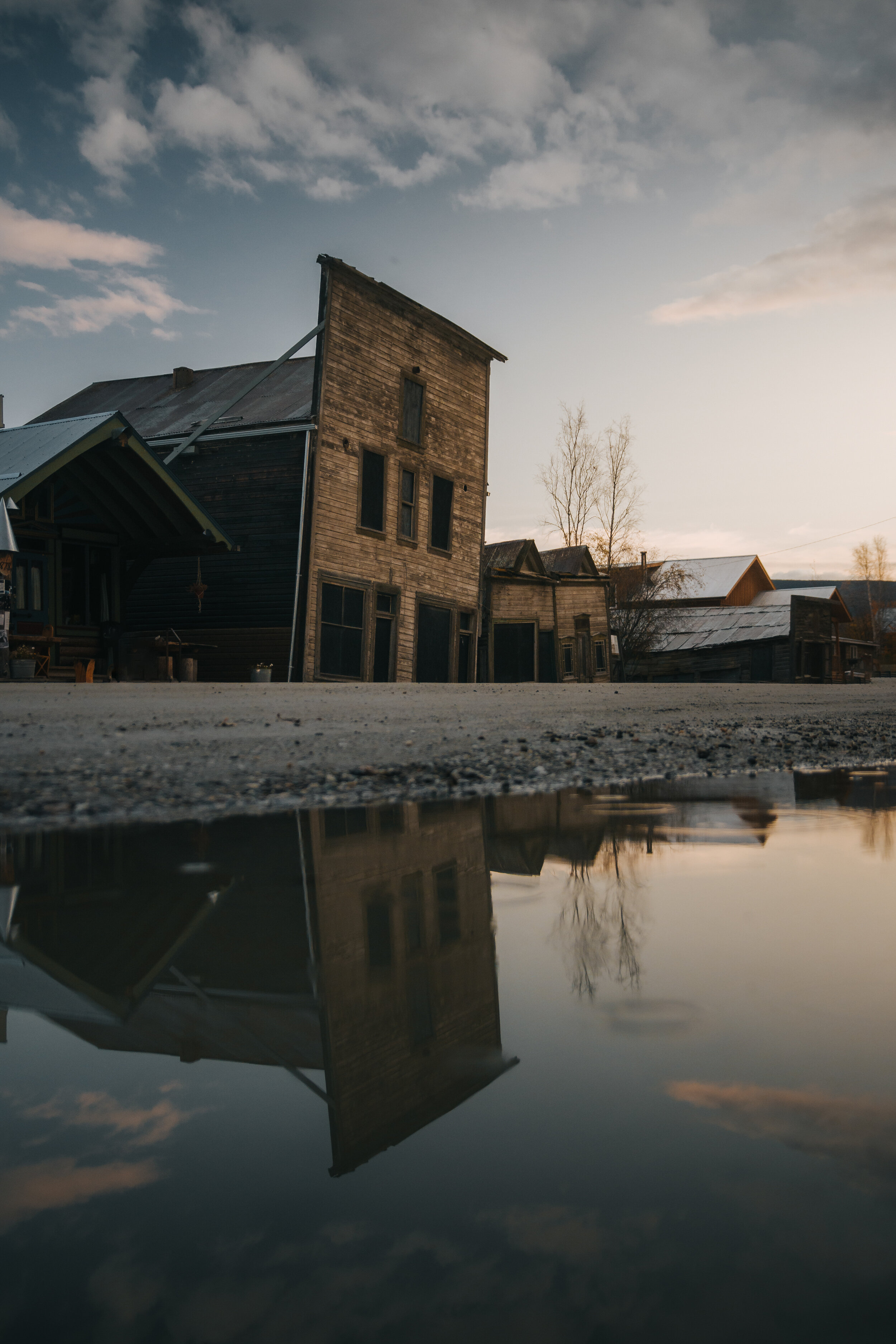
Turning north we set out for Dawson City and the Dempster Highway. Dawson City is the second largest city in The Yukon, with a population of 1400. Originally a first nations camp, it exploded when gold was discovered and eventually reached a population of 40,000 by 1898. Three years later after the gold rush the population plummeted to 8,000.
Girando hacia el norte, nos dirigimos a Dawson City y Dempster Highway. Dawson City es la segunda ciudad más grande del Yukón, con una población de 1400. Originalmente un campamento de las primeras naciones, explotó cuando se descubrió oro y finalmente alcanzó una población de 40.000 en 1898. Tres años más tarde, después de la fiebre del oro, la población se desplomó a 8.000.

The town itself still retains many of its original buildings, many of which are sinking at strange angles due to the melting of the permafrost. One such place is Downtown Hotel's Sourdough Saloon, where we engage in a hundred-year old tradition of drinking the “Sourtoe Cocktail”: a shot, typically of Yukon Jack, with a dead, frostbitten, human toe in it. There is one rule: “You can drink it fast, you can drink it slow, but your lips have gotta touch the toe”.
La ciudad en sí todavía conserva muchos de sus edificios originales, muchos de los cuales se están hundiendo en ángulos extraños debido al derretimiento del permafrost. Uno de esos lugares es Sourdough Saloon del Downtown Hotel, donde participamos en una tradición centenaria de beber el "Cóctel Sourtoe": un trago, típicamente de Yukon Jack, con un dedo del pie humano muerto y congelado. Hay una regla: "Puedes beberlo rápido, puedes beberlo despacio, pero tus labios deben tocar el dedo del pie".


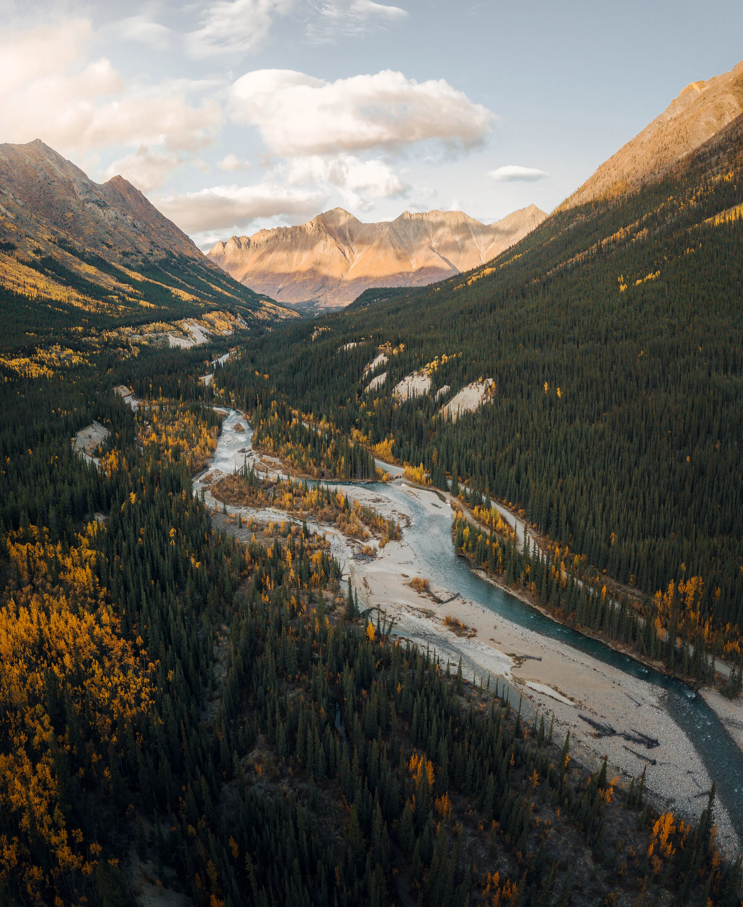
The final leg of our journey becomes a race against winter as we push north on the Dempster Highway towards the Arctic Circle and Tombstone Territorial Park.
El tramo final de nuestro viaje se convierte en una carrera contra el invierno a medida que avanzamos hacia el norte por Dempster Highway hacia el Círculo Polar Ártico y el Parque Territorial Tombstone.

Quickly the taiga gives way to tundra, and the landscape becomes even more dramatic, with massive, jagged peaks that mimic those seen in Patagonia.
Rápidamente, la taiga da paso a la tundra y el paisaje se vuelve aún más dramático, con picos masivos e irregulares que imitan a los que se ven en la Patagonia.


A mere hundred kilometers from the Arctic Circle the first snows begin and we are forced to turn south, making our way back to Whitehorse and warmth. In every direction we see the north beginning its transition into a long and cold winter, yet our hearts remain warm and full in the promise of Spring and another adventure in a land that is larger than life.
A solo cien kilómetros del Círculo Polar Ártico comienzan las primeras nevadas y nos vemos obligados a girar hacia el sur, de regreso a Whitehorse y al calor. En todas direcciones vemos el norte comenzando su transición hacia un invierno largo y frío, pero nuestros corazones permanecen cálidos y llenos con la promesa de la primavera y otra aventura en una tierra que es más grande que la vida.